Private forecaster tips massive rains for Alice
20 March 2019
 By ERWIN CHLANDA
Alice Springs could be in for downpours of 30mm to 50mm with a likelihood of the Todd River flash flooding on the weekend in the wake of a cyclone currently in the Gulf of Carpentaria.
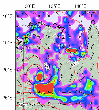
Victoria-based independent weather forecaster Dennis Luke gave the Alice Springs News Online a map (pictured) from a reputable meteorological office which he asked to not have named, showing massive rainfalls at 10am on Sunday.
Preceding images the News has seen show several smaller storms starting from where Tropical Cyclone Trevor will make landfall. They consolidate as they are moving south-west into a single rain cell over The Alice.
The town’s coordinates are 23.6980° S, 133.8807° E.
Mr Luke says he is not a professional but over 22 years has predicted drought, storms and floods.
He believes the cyclone, mixed in with the monsoon, will become a tropical depression as the system travels over land.
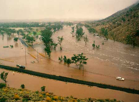
The most recent very large rainfall with serious flooding was in 1988 (at left – looking north-east from the western flank of The Gap).
This is how Meteorologist Grace Legge of the Australian Bureau of Meteorology describes the weather ahead:-
“There is a tropical cyclone watch from Nhulunbuy to the NT / Qld border including Groote Island where gale force winds in excess of 65 km/hr can be expected from Friday.
 “Wind gusts to 120km/hr are expected to develop on Groote Island from Friday morning and extend to the mainland coast between Cape Shield and the NT Border later Friday.
“Gales could also extend further north to Nhulunbuy on Friday if the cyclone takes a more northerly track,” says Ms Legge, from the bureau’s NT Regional Office.
“Depending on the movement of the system, very destructive winds with gusts to 250 km/hr, heavy rainfall and very dangerous storm tides are expected near the centre of the system as it approaches and crosses the NT coast.
“Once the system has moved inland it will weaken but could maintain tropical cyclone intensity for over 24hrs as it continues to move further inland.
“This system is likely to bring significant rainfall with it, daily falls of 100-200mm are possible at Groote Eylandt and through the Carpentaria district as the system approaches and makes landfall.
“Heavier falls of 200-300mm are possible around the core of the system.
“The area of heavy rainfall will be highly dependent on the movement of the system and where it directly impacts the coast.
“Heavy rainfall and strong winds are likely to continue inland and may impact the Barkly district this weekend and early next week.”
The Barkly isn’t quite Alice Springs, so we’ll wait and see.


I recall when we had a “psychic” published in the Advocate forecasting rain for February a few years back … it never rained.
Heavy rains will certainly be welcome, no doubt about it Ed, but 30 to 50mm is a long way short of what’s required to produce floods like the one pictured.
That kind of flood requires closer to 200mm over a fairly short period of time … wouldn’t that be nice?
50mm won’t flow the river.
This co-incides very nicely with the 30+ 1 or 2 years cycle of heavy rain in The Centre which we have seen over the last 100 years, usually caused by cyclone activity in the north of Australia.
By the way, I am very happy if it does rain as this bloke predicts.
PLEASE NOTE: If we cannot reach you on the email address you provide, because an email we send to it is “undeliverable” for example, your comment will not be published. Editor.
Hello Erwin. From an ex Alice Springs resident.
Flood mitigation – an election promise?
As I type this comment, the path of Tropical Cyclone Trevor is now forecast to head directly for the massive McArthur River zinc, lead and silver mine near Borroloola.
I guess we will soon see if this precipitates a major environmental disaster in that vicinity.
Not that we will hear about. Good old government cover up.
Psychics are a bit like weather forecasters. Get the right weather, just the wrong date. LOL
Interesting to see private weather forecasting is still a thing.
It has a long history in Australia, especially popular with farmers of course, and has had its share of well-known identities such as long-range forecaster Lennox Walker, trained by fellow Queenslander, Inigo Jones.
Mr Jones was the weather observer at Crohamhurst QLD in 1893 when the Australian record of 907mm fell in 24 hours.
The seve-day total at this station was 2112mm so Mr Jones must have been kept very busy emptying out the gauge! The great flood of Brisbane that followed is of course one of Australia’s greatest natural disasters.
It rains so little in Alice Springs for such long periods that it’s easy to be complacent, but given the 700m elevation and latitude on the Tropic of Capricorn, there is no reason a monsoon trough or tropical low couldn’t dump a massive amount of rain in a short period.
Additionally there is the amount of bare rock, relatively low vegetation cover, climate change, and the bottleneck of the Gap to consider.
If you look at the 14 or so major rainfall events since 1910 there is a distinct pattern of getting around 200mm over five or so days which is fairly benign.
The 1988 flood was a bit different in that 200mm fell in a single day – the highest daily rainfall.
The other fairly “sharp” events were 1910 and 1920 where 200mm+ fell over three days.
By comparison the good flow back in 2015 was 190mm over five days (average 38mm per day). Similarly, big flows in the 1970s and early 2000s were from steady rain over a week.
The real question is whether getting 200mm in a day is at the upper end of possibilities or whether there is something bigger to come.
Certainly NASA’s studies of Central Australia’s geomorphology in the 1990s in preparation for the Mars Rover missions suggested potentially devastating floods had likely occurred in just the last 1000 years.
I used to be amazed at the different alluvial layers in the soil as you dug postholes in our garden on the Eastside, each layer deposited by some paleo-flood.
I suppose though, given it’s now been 100+ years of records, only having one day of 200mm so far ain’t too bad. Fingers crossed.